
Peckham Street-O, Tuesday 8 October
The 2024-25 Street-O series kicks off in bustling Peckham. The format is a 1 hour time limit to find as many checkpoints as you can. It’s a great way to explore the local area.
Entries now open on SiEntries.
Race HQ
The event base is The Montpelier. You can leave your bags here (items left at your own risk).
Peckham Rye is the nearest rail station with connections from Victoria, London Bridge, Blackfriars, Clapham Junction, Dalston Junction, Gravesend, Sevenoaks and Beckenham Junction. Rye Lane in the middle of Peckham has several bus routes running through it to lots of destinations.
The Montpelier is a 5 minute walk from the station. Turn right out of the ticket gates, down the small alley and turn right onto Blenheim Grove, left onto Choumert Grove then right onto Choumert Road. The Montpelier is on your left. We have a space at the back booked.
Stick around for a social afterwards and discuss your route with others. The pub serves a good choice of food and drink.
| Location | Peckham |
|---|---|
| Address | The Montpelier, 43 Choumert Road, London, SE15 4AR |
| Latitude/longitude | 51.4681, -0.0704 |
| OS grid reference | TQ341761 |
| Maps | Google Maps, OpenStreetMap |
/-0.070416,51.468131,14,0,0/455x455@2x?access_token=pk.eyJ1Ijoib29icmllbiIsImEiOiJjaWwyb2d6M2MwMGM2d2dtNXI0Y2dobjdkIn0._yVvYZuMnUokZRhdRs0ysQ)
| |
Race Details
Entry is online only via SiEntries.
Entry fee is £3 for SLOW, LOK, DFOK members, students and juniors and £5 for others. You will get a specially produced street map showing the control points you need to find. You will need a timing chip – so bring your own SI/SIAC if you have one, otherwise you can hire one for £1.
Groups or pairs are welcome. Make as any entries as you want maps (e.g. if you are running in a pair and want a map each then make 2 entries). On SiEntries the entry options are “Individual” (you get your own timing chip and map) and “Group (2-5)” (one timing chip and map in the group). You can make a combination of “Individual” and/or “Group (2-5)” entries. The “Group (2-5)” option is to ensure we capture the names of all participants.
All competitors take part at their own risk, and because of our insurance any under-16s must be accompanied by a parent or guardian.
If you’re not a SLOW member, do consider joining.
For the event, you’ll need to bring running gear, a watch or timepiece to keep track of time, and a pen or pencil to fill in the answers on the cluesheet. A compass is not essential! Despite being before the clocks go back sunset will still be early enough at 18:21 that we advise you bring headtorches to aid running and reading the map. The club has a small number available to loan – please get in touch before the event to arrange this should you need one.
Like all our Street-Os, this a public race – all are welcome.
| Registration | Between 1815 and 1915 |
|---|---|
| Start Times | Between 1830 and 1930 |
Format
We’ll be using the same ‘score’ format as previous years, where you have 60 minutes to collect as many points as possible. Using the map provided, find controls in whichever order you like, collecting 10 points for each control starting with a 1, 20 points for each starting with a 2 and so on. As the controls are worth differing points, there are some tactics in deciding where to go. If you’re late, the penalty is 1 penalty point for every 2 seconds late back (so you’ll lose 30 points if you are a minute late back etc.). This guide provides general information about street orienteering.
1. Collect your timing chip (if necessary).
2. At the start, the start official will give you the map and clue sheet. Write down your name on the clue sheet. When you are ready to start, “dib” your timing chip to start your time and your 60 minute countdown.
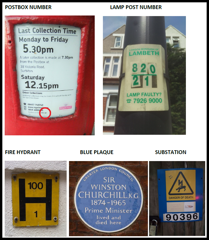
3. Find controls in whichever order you like. At each location you’ll fill in the answer to the question on the clue sheet to prove that you’ve been there.
4. Return to the finish and “dib” the finish box to stop your time. Come back within 60 minutes to avoid time penalties. If you don’t want to be out for a full 60 minutes you can come back earlier.
5. Report back to the registration desk after you’ve finished and hand in your clue sheet to be marked. You can collect this after it has been marked and score recorded. Full final results will be posted on the website as soon as possible.
If you have any questions, do ask them on the SLOW Facebook or email the organiser James on

Helpers
We need helpers on the night. Get in touch with James if you can help. Roles can be found on our “Helpers Required!” page.